

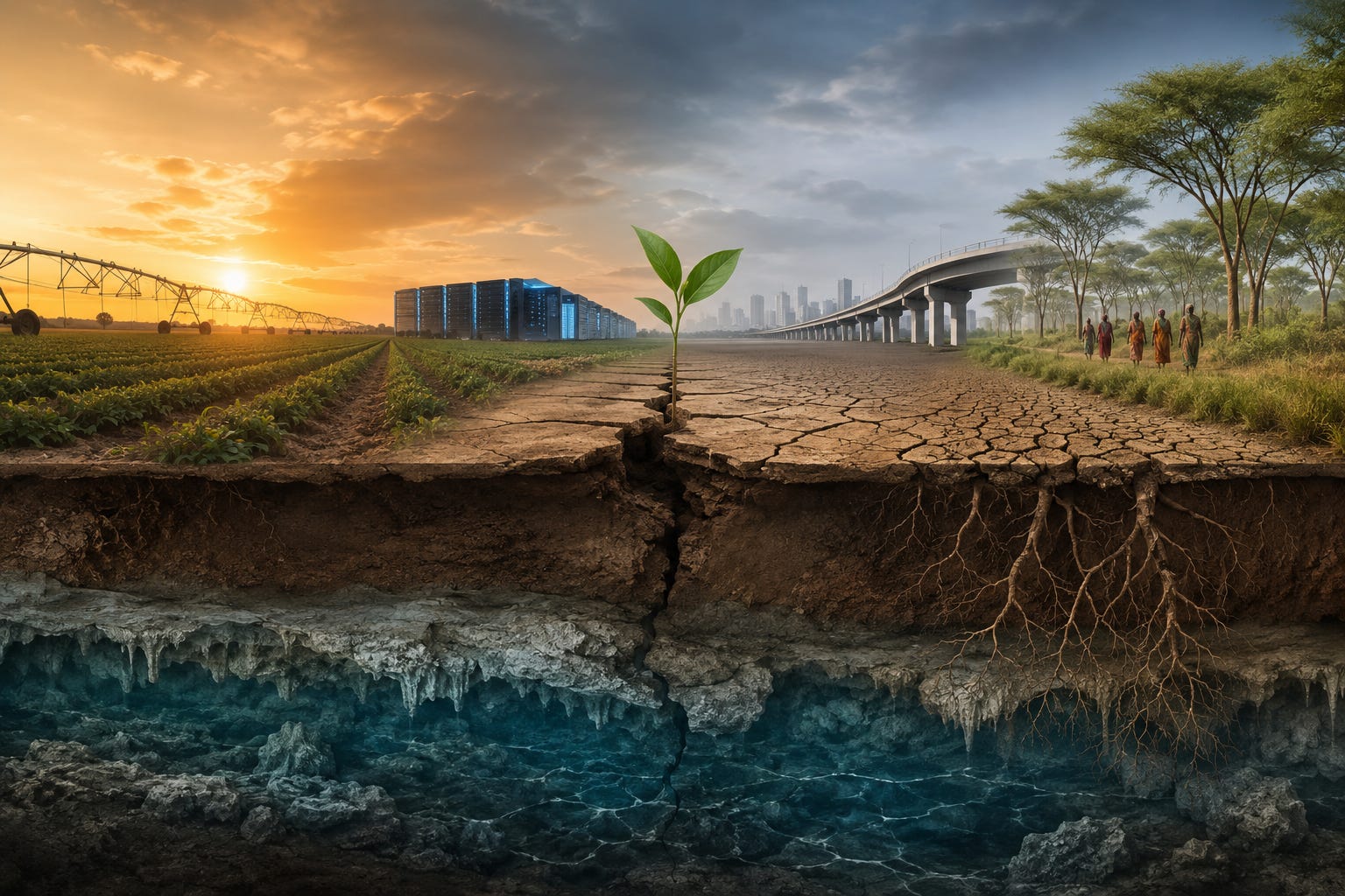
Beneath the Surface
An underground aquifer, disappearing scientific data, transportation debates, and a line of trees across Africa reveal a common question about how societies prepare for the future.

Beneath the farms, ranches, towns, and highways of the Great Plains lies one of the most important pieces of infrastructure in the United States, one that most Americans will never see.
Stretching beneath parts of eight states, the Ogallala Aquifer quietly supplies drinking water to communities and irrigation water to one of the nation’s most productive agricultural regions. The food on grocery store shelves, the crops harvested each year, and the economies of countless rural communities all depend, in part, on a resource hidden hundreds of feet below the surface.
For decades, scientists have warned that portions of the aquifer are being depleted faster than nature can replenish them. At first glance, that may seem like another environmental headline, but at a moment when national conversations increasingly revolve around artificial intelligence, energy production, drought, pollution, and the future of American agriculture, the Ogallala raises a broader question. When seemingly unrelated headlines keep pointing toward the same resource, are we looking at isolated problems or different symptoms of the same underlying challenge?
Support independent media that follows the power.
The Coffman Chronicle is built to track who holds power, who abuses it, who profits from it, and who pays the price.
Paid supporters get full Tony Michaels Podcast episodes, deeper transcript analysis, paid columns, archives, and the reporting framework behind the show.
If you believe independent media has to survive outside billionaire platforms, corporate media, and party-approved gatekeepers, become a paid supporter today.
The Ogallala: America’s Invisible Water Infrastructure
Despite the way aquifers are often portrayed, the Ogallala is not an underground lake. There are no vast caverns filled with water beneath the Great Plains. Instead, the aquifer is a massive network of ancient sands, gravels, silts, and clays deposited over millions of years as rivers flowing from the Rocky Mountains spread sediment across the region. Water occupies the tiny spaces between those sediments, creating an enormous underground reservoir that slowly stores and releases groundwater. It is more of a sponge than a body of water, as most think of one.
Unlike a reservoir that can visibly fill after heavy rains, groundwater “recharge” or replacement is often a slow process. Rain and snow that fall on the landscape must first soak into the soil before gradually moving downward through layers of sediment until they reach the aquifer. How much water ultimately arrives depends on numerous factors, including geology, soil conditions, vegetation, precipitation, and the rate at which water is withdrawn. Recharge rates vary dramatically across the Ogallala, and in many areas, water is being pumped faster than it can naturally be replaced.
The scale of the aquifer is essential to understanding why it is so important. The Ogallala underlies approximately 174,000 square miles across Colorado, Kansas, Nebraska, New Mexico, Oklahoma, South Dakota, Texas, and Wyoming. According to the U.S. Geological Survey, it supplies roughly 30% of the groundwater used for irrigation in the United States, supporting about one-fifth of the nation’s irrigated agricultural land, and is the primary source of drinking water for numerous communities.
USGS estimates indicate that, compared with conditions before widespread groundwater use development, the aquifer had lost roughly 10% of its recoverable groundwater storage by 2019. That figure is an average across an enormous region. Some areas have experienced relatively modest changes, while others have seen much steeper declines as irrigation demands, population pressure, climate conditions, and local geology interact in different ways.
The Ogallala is more than simply a water source. It is natural infrastructure. Like a bridge, a power grid, or a transportation network, it quietly performs a function that millions of people depend upon every day without ever thinking about it. And, like any critical infrastructure, its condition today influences what it will be able to support tomorrow.
Why the Ogallala Matters Now
The Ogallala Aquifer has not suddenly become important. Scientists have been studying it for decades, and concerns about declining groundwater levels are not new. What has changed is the number of national conversations that increasingly point back to the same finite resource.
Water is no longer discussed primarily as an agricultural issue. It now appears in conversations about artificial intelligence due to data center water usage for cooling, and discussions about energy production, since many forms of electricity generation also depend on reliable water supplies. It surfaces in debates over drought, pollution, land use, and population growth as communities compete for the same resources.
Understanding the aquifer also requires setting aside one common misconception. It is tempting to imagine groundwater as a giant underground lake that fills again after a wet year. In reality, groundwater behaves much more like a savings account than a checking account.
Rain and snow replenish the aquifer slowly through a process known as recharge. Water seeps through soil and layers of sediment before eventually reaching the underground formations where it can be stored. Depending on local geology, climate, and groundwater depth, that process may take years, decades, or much longer. At the same time, irrigation, municipal water systems, and industry can withdraw large volumes over relatively short periods.
This does not mean the aquifer cannot recover. Some areas have stabilized or even experienced modest improvements through changes in water management, reduced pumping, or favorable weather conditions. Other areas continue to see declines.
Those regional differences illustrate the complexity of the issue. The question is not simply how much water remains underground. Scientists are also trying to understand how rainfall patterns, geology, land use, irrigation practices, and a changing climate interact over time. Answering those questions requires consistent monitoring, long-term data collection, and a willingness to study processes that often unfold over decades or even centuries rather than news cycles.
For most Americans, the Ogallala remains out of sight and out of mind, yet every harvest, growing season, and drought quietly depends on decisions being made about a resource that few people will ever see.
That begs the question. If some of the nation’s most important infrastructure is largely invisible, how do we know when it is under stress?
Seeing the Cracks Before They Appear
One of the challenges of maintaining any critical infrastructure is that serious failures rarely happen without warning. Long before a bridge is closed or a dam fails, engineers are typically looking for smaller signs that something is changing. Tiny cracks, shifting foundations, corrosion, and unusual stress patterns may not pose an immediate danger, but they can signal larger problems developing beneath the surface.
Those inspections are easy to overlook because success rarely makes the news. When maintenance works as intended, the bridge remains open, traffic keeps moving, and most people never think about the engineers collecting data behind the scenes.
Natural systems require much the same approach. However, an aquifer cannot be inspected with a flashlight, nor can scientists immediately see how decades of changing rainfall, irrigation, land use, or groundwater withdrawals are reshaping an underground system spread across thousands of square miles. Instead, researchers rely on thousands of measurements collected over time. Water levels are tracked in monitoring wells. Stream flows are measured. Soil moisture, precipitation, groundwater quality, and weather patterns all contribute pieces of a much larger picture.
That steady collection of information is not simply an academic exercise. It allows scientists to identify trends, test assumptions, and evaluate whether conservation efforts, policy changes, or new technologies are actually improving conditions. Without those measurements, it becomes far more difficult to distinguish temporary fluctuations from long-term change or to determine whether a proposed solution addresses the underlying problem.
Recent debates surrounding the National Oceanic and Atmospheric Administration (NOAA) illustrate why that distinction matters. Although many Americans associate NOAA primarily with weather forecasts, the agency also supports extensive environmental monitoring that helps scientists understand oceans, climate, fisheries, coastal conditions, and other interconnected systems. Earlier this year, concerns over staffing reductions prompted some displaced researchers to organize independent efforts to preserve scientific capacity, while proposals affecting long-running environmental monitoring programs sparked public debate before some were ultimately reconsidered.
Whatever one’s views on those individual policy decisions, they highlight a broader question. How should society maintain the knowledge needed to understand complex natural systems over decades rather than election cycles? Collecting data does not solve a problem by itself, but it enables informed responses. Without it, policymakers, communities, and industries alike risk making decisions with only a partial understanding of the conditions they hope to improve.
The same principle applies whether the subject is a bridge, an aquifer, or the atmosphere. The visible crack is rarely the beginning of the story. More often, it is the point at which years of accumulated stress become impossible to ignore. The purpose of monitoring is not simply to document failure. It is to recognize the quieter signals early enough that failure may never occur at all.
What Problem Are We Solving?
Once a system begins showing signs of stress, the next question seems straightforward. How do we fix it?
In practice, that question is often more complicated than it first appears because the solution depends on how the problem is defined. If two people describe the same challenge differently, they may propose entirely different responses while believing they are solving the same issue.
Water offers a useful example. If the problem is having too little water available today, the first response may be to drill deeper wells, construct new reservoirs, or move water from somewhere else. Those approaches can be valuable under the right circumstances, particularly during emergencies or periods of rapid growth. They can address an immediate need.
A different question, however, produces a different set of solutions. Why is demand increasing? Why is recharge failing to keep pace with withdrawals in some areas? How are changing weather patterns, agricultural practices, population growth, industrial development, and land management influencing one another? Are there ways to reduce pressure on the system itself rather than continually increasing the amount we extract from it?
Those questions do not reject the first set of solutions. They simply widen the frame.
The same pattern appears well beyond water. Recent discussions surrounding transportation infrastructure, for example, have focused on proposals to make certain roadways more efficient for freight movement. Improving freight transportation may be a worthwhile goal. Yet before deciding how to optimize a corridor, another question naturally follows. What transportation problem is this particular project intended to solve?
If freight is already moving successfully through existing road, rail, air, or pipeline networks, is this corridor a significant bottleneck? Would freight carriers actually use the route once improvements are complete? Does the surrounding infrastructure support heavier commercial traffic? How might those benefits compare with the costs, both financial and environmental?
Those questions are not arguments against expanding infrastructure, but rather part of understanding whether a proposed solution matches the problem it seeks to address.
The same reasoning applies to agriculture, energy, housing, and countless other public policy debates. Increasing production, expanding capacity, or accelerating development may each provide meaningful benefits. At the same time, those decisions can influence the long-term condition of the natural and built systems that enable future growth.
That may be one of the most important questions raised by the Ogallala. A society can become exceptionally skilled at solving today’s visible challenges while paying less attention to the slower changes occurring beneath the surface. The visible problem may disappear for a time, even as the underlying pressures continue to build.
The Time Scale of Success
Every important system operates on its own timeline. Businesses often measure performance by the quarter, while governments work within annual budgets and election cycles. Infrastructure projects may be designed to last decades, while forests grow over generations. Aquifers recharge over years, decades, or even centuries, depending on where they are located and the geology beneath them.
None of those timelines is inherently right or wrong. Problems arise when decisions are evaluated on one timescale while their consequences unfold on another.
The Ogallala illustrates that tension particularly well. Water can be withdrawn in minutes. In many places, replacing that water naturally may take years or much longer. The benefits of pumping are immediate. The costs, however, may not become fully apparent until years later, when declining water levels begin to affect farms, communities, ecosystems, and future economic opportunities.
That same pattern appears in many of today’s public debates. Artificial intelligence promises enormous advances in science, medicine, and the economy. At the same time, new data centers require reliable electricity supplies and, in many cases, substantial amounts of water for cooling. Transportation projects may improve the movement of people or goods while also reshaping landscapes that took centuries to develop. Agricultural policies can increase production while raising important questions about soil health, groundwater, affordability, and the long-term resilience of the food system.
None of those examples suggest progress should stop. Instead, they suggest that progress can be measured in more than one way. One measure asks what a decision produces today. Another asks what condition it leaves behind for tomorrow.
That distinction is easy to overlook because the benefits and costs often arrive on different schedules. Increased production, faster transportation, or expanded development can usually be measured quickly. The gradual loss of groundwater, declining soil health, deferred infrastructure maintenance, or ecosystem change often unfolds slowly enough that each individual year appears manageable. By the time the cumulative effects become visible, the choices that contributed to them may stretch back decades, even generations.
This is why monitoring is so essential. It gives society the opportunity to compare today’s gains with tomorrow’s capacity before those two timelines drift too far apart. Data cannot eliminate difficult tradeoffs, but it can reveal whether the systems supporting today’s prosperity are becoming stronger, weaker, or simply more difficult to understand.
Perhaps that is why so many seemingly unrelated headlines feel connected. Whether the subject is water, agriculture, transportation, energy, or scientific research, each is asking a version of the same question. How should decisions made today account for systems that must continue functioning long after today’s news cycle has ended?
A Different Way to Ask the Question
If the stories examined so far have one thing in common, it is that they describe systems under strain. Groundwater levels decline, infrastructure ages, scientists debate how to sustain long-term monitoring, and policymakers weigh competing priorities as they try to solve immediate problems. The remaining question is whether there is another way to approach those problems.
One example comes from thousands of miles away in Africa, where the Great Green Wall initiative has spent years working to slow the spread of desertification across the Sahel, a vast semi-arid region stretching across the continent. The project is often described simply as a tree-planting campaign. While trees are certainly part of the effort, that description captures only a small part of what participants are trying to accomplish. The broader objective is to improve the condition of the landscape itself.
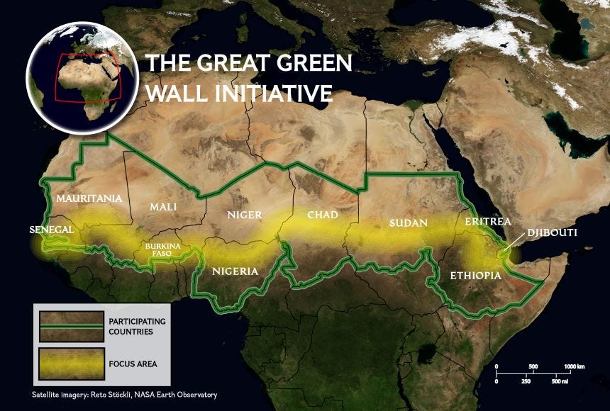
National Geographic
Healthy vegetation helps stabilize soil, reducing erosion from wind and heavy rains. Root systems allow more water to soak into the ground rather than quickly running off the surface. Organic matter returned to the soil improves its ability to retain moisture during dry periods. As vegetation returns, local temperatures may moderate, wildlife habitat can improve, and agricultural land may become more productive over time. Communities participating in restoration efforts also hope to strengthen local economies and improve long-term food security.
Whether every one of those goals will ultimately be achieved remains an open question. The Great Green Wall is an ambitious project unfolding across multiple countries, climates, governments, and communities. Like any large-scale initiative, its long-term success will depend on continued adaptation, investment, and careful evaluation.
What makes the project noteworthy is not that it offers a perfect solution, but rather that it begins from a different premise. Rather than asking how to extract more from a landscape already under stress, the project asks how to restore the landscape’s ability to support the people who depend upon it. Individual actions, such as planting trees or restoring degraded land, are not viewed as isolated accomplishments. They are intended to strengthen a system in ways that may produce multiple benefits over time.
That idea reaches beyond environmental restoration. A bridge is not maintained simply to preserve concrete and steel, but because communities depend upon what the bridge makes possible. Farmers do not improve soil only to grow healthier plants this season. They do so because healthy soil supports future harvests. Scientists do not collect decades of environmental observations merely to produce reports, but because understanding how systems change over time enables better decision-making.
The Ogallala Aquifer took shape over millions of years. The water supporting farms and communities today accumulated through natural processes operating on timescales far longer than any budget cycle, business plan, or election. That does not mean it should never be used. It means the choices surrounding its use inevitably become questions about time as much as technology.
The same principle may apply to many of today’s public debates. Sometimes the most valuable investment is not the one that produces the greatest immediate return. Sometimes it is the one that leaves the underlying system better equipped to support whatever comes next.
If this article challenged you to see today’s headlines a little differently, consider subscribing.
Our goal isn’t simply to tell you what happened. It’s to explore the deeper questions beneath the news, connect stories that often seem unrelated, and examine the systems shaping our communities, institutions, and future.
If that kind of journalism resonates with you, we’d be honored to have you join us.
Sources:
“Water-level and recoverable water in storage changes, High Plains Aquifer, predevelopment to 2019 and 2017 to 2019,” U.S. Geological Survey, May 2024.
“Impacts to the Ogallala Aquifer: How Changes in Long-term Climate Trends May Affect the Future of Agriculture in the Region,” USDA Climate Hubs, December 2024.
“Warning about aquifer’s decline sets up big fight in Kansas,” Associated Press, January 2023.
“Majority of US’s new AI datacenters to be built on drought-hit land,” The Guardian, June 8, 2026.
“Trump administration reverses decision to scrap ocean monitoring system,” The Guardian, June 18, 2026.
“Lummis signs on to ‘Trump Interstate,’ to run through Grand Teton Park,” KHOL 89.1 FM, May 19, 2026.
“Proposed ‘Trump Interstate’ would run through portions of Grand Teton and Madison Valley,” Explore Big Sky, May 19, 2026.
“Great Green Wall Initiative,” United Nations Convention to Combat Desertification.
“A green wall to promote peace and restore nature in Africa’s Sahel region,” United Nations Environment Programme, February 22, 2023.
“The Great Green Wall,” National Geographic Education, September 3, 2025.
“European State of the Climate 2025: record heatwaves from Mediterranean to Arctic while glaciers shrink and wildfires rage,” World Meteorological Organization, April 29, 2026.
All I can say is wow! I had never heard of the Ogalala aquifer before. I found this article really really interesting and I like the fact that I learned a lot. I wish my brother was still alive. He was a professor at Syracuse University in the geology department. I would’ve loved to discuss this with him. Thank you.